
Maps for Garmin based on OpenStreetMap


Known issues
Garmin maps format is not public, so map generation process (done with mkgmap) is based in reverse engineering. As format has not been completely deciphered yet, there's still a number of problems affecting the maps. They have the advantage that data on them are most probably more up to date than commercial ones, although in some areas coverage is lower. Another great advantage is that anyone can complete or correct missing or wrong data. Below there is a list of known issues regarding the use of the maps.
- Address search: in order to find a given street using 'Search by address' option of the GPS it is necessary to type the name of the street exactly as it is on the map, e.g. 'Calle de los Derechos Humanos' (Human Rights Street). It may be a problem for languages like Spanish or French, in which the name of the way is preceded by the type of way: Avenida de América, Paseo de la Castellana, etc. as it will be difficult to know how the name of a street is in the map: it may be Calle Derechos Humanos, C/ de los Derechos Humanos, Avenida América, etc.
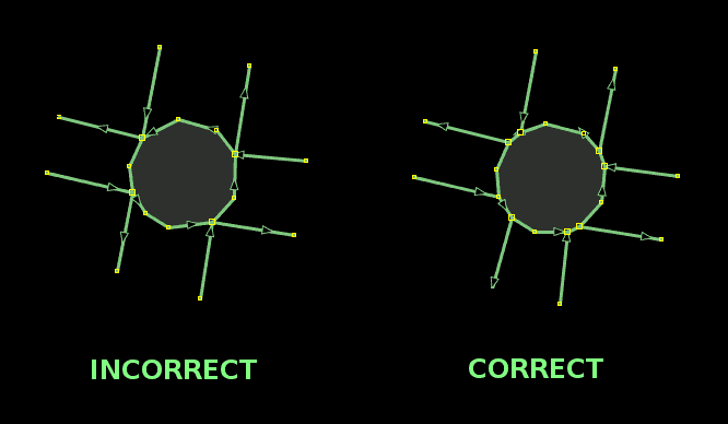
To avoid this, some changes are introduced that let you omit the type of way and also particles before the main part of the name. For the examples above, typing “Derechos Humanos”, “América” or “Castellana” will be enough. Some irrelevant words common at the end of street names, like Avenue, Street, Road (English), Strasse, Weg (German), kalea, bidea (Basque), etc. are also removed. - Roundabouts exit number: if a way entering a roundabout shares a node with an exiting way, that exit is not taken into account for the 'Take exit # to the right' instruction, although on screen it is correctly displayed. In fact, it is caused by errors in the data used to generate the map, and must be fixed on OpenStreetMap data.
- Advanced functions: some advanced functions, such as lane indication, on screen speed limit display, crossing search, etc. don't work.
- Topographic maps on MapSource: contour lines behavior in MapSource is quite variable, some times they are displayed and some times they are not, without a known motive, just showing the number that indicates the height but not the line. However, although they are not seen, they are there and can be used, for example, to calculate a route profile (Edit menu->Route Properties->Show Profile...). On BaseCamp and QLandkarte GT this problem doesn't occur.
If you detect any other problem in the maps, other than those due to errors or lacks in OpenStreetMap data, please use the comments at the en of this page to report it.
You can leave your comments on this page below:
Comments (64)
Topic: Problems
Sort


In the map for my area, a couple of streets appear as continuous, but they are not. They are actually separated by a wall, so you can't drive thru them. How do I fix that, or how do I report it to be fixed?
Admin:
You can zoom in to the affected area at OpenStreetMap web site, then click Share button at the right hand side bar of the page and send the link here. If you want to make further edits, I suggest you create an OSM account and edit data yourself.
 Reply
Reply Permalink
 Flag
Flag 0
0 0
029th December 2016 10:25pm


Hi,
I have downloaded the OSM Base Map for India to a Nuvi42 device on the SD card in a directory named as Germin. The map was recognized properly by the device and I was able to open it successfully. But the search function is not working on the OSM Base Map. I was not able to search any place. Please help me out.
Thanks in advance.
Admin:
Are you searching in an area far away from the place you used the GPS for the las time? If so, please have a look at the FAQ. If not, please give some more details: what are you looking for? Addresses? Cities? POI?
29th October 2016 12:04am

Christoph Jungkurth (Dornstetten, Germany)
Hi,
Using the Australia-maps I found a bad bug as a "virtual lap" on the A 87 between Post Augusta and Coober Pedy, that introduces severe "misrouting"!?!
Using the Australia-maps I found a bad bug as a "virtual lap" on the A 87 between Post Augusta and Coober Pedy, that introduces severe "misrouting"!?!
Admin:
There's a portion of A87 which is tagged as aeroway=runway + highway=trunk. While building the map aeroways are taken first and then that portion is not used as highway, creating a gap in the road, that cousing the lap you see in your route. Before introducing any change, I first would like to know if that portion of A87 is really used as aeroway. Could you confirm it?
15th July 2016 10:02am
Christoph Jungkurth (Dornstetten, Germany)
Maybe it is kind of an emergency-runway, but in 99% of time it is a normal highway. In the published form it causes misrouting.
Admin:
I have modified map compilation so that it includes this kind of highways+runways, so the issue should be fixed now.
17th September 2016 4:50am

This is a question. Rating is not 5 because in Jamaica we drive on the left. Roundabouts therefore go CLOCKWISE. The Central America Map instructs you to go ANTI-CLOCKWISE at every roundabout. Is there a way to compile the map so that roundabouts in countries that drive on the left go CLOCKWISE? Otherwise maps are pretty much perfect and up to date.
Admin:
This problem occurs when a map contains countries which drive on both sides. I'll try to find a solution for the Central America one.
Please try now the map, it's working correctly now in Jamaica for me.
Please try now the map, it's working correctly now in Jamaica for me.
10th February 2016 8:26pm
Page 11 of 13