
Maps for Garmin based on OpenStreetMap


Map Legend
Lines
| Description | Day | Night | OpenStreetMap Tags |
|---|---|---|---|
| Motorway |  |  | highway=motorway |
| Toll motorway |  |  | highway=motorway + toll=yes |
| Bridge | 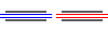 |  | highway=motorway + bridge=yes |
| Tunnel |  |  | highway=motorway + tunnel=yes |
| Trunk road |  |  | highway=trunk |
| Primary road |  |  | highway=primary |
| Secondary road |  |  | highway=secondary |
| Bridge |  |  | highway=* + bridge=yes |
| Tunnel |  |  | highway=* + tunnel=yes |
| Tertiary road |  |  | highway=tertiary |
| Bridge |  |  | highway=tertiary + bridge=yes |
| Tunnel |  |  | highway=tertiary + tunnel=yes |
| Residential road |  |  | highway=residential |
| Oneway residential road |  |  | highway=residential + oneway=yes |
| Service road |  |  | highway=service |
| Road link |  |  | highway=*_link |
| Unpaved track |  |  | highway=track + tracktype=grade2 |
| Unpaved track |  |  | highway=track |
| Unpaved track (uphill) |  |  | highway=track + incline=up|incline>0 |
| Unpaved track (steep uphill) |  |  | highway=track + incline>10 |
| Roundabout |  |  | highway=* + junction=roundabout |
| Path |  |  | highway=path |
| Road under construction |  |  | highway=construction |
| Cycleway |  |  | highway=cycleway |
| Steps |  |  | highway=steps |
| Barrier |  |  | barrier=* |
| Railway |  |  | railway=rail |
| Tunnel (Railway) |  |  | railway=rail + tunnel=yes |
| River |  |  | waterway=canal, river, rapids |
| Intermittent river |  |  | waterway=* + intermittent=yes |
| Stream |  |  | waterway=stream |
| Ferry |  |  | route=ferry |
| International border |  |  | |
| Regional border |  |  | |
| Municipal border |  |  | |
| Minor contour line (20 m) |  |  | |
| Intermediate contour line (100 m) |  |  | |
| Main contour line (500 m) |  |  | |
| Runway |  |  | aeroway=runway |
| Pipe |  |  | man_made=pipe |
| Power line |  |  | power=line |
| Cliff |  |  | natural=clif |
| Cattleway |  |  | route=transhumance, cattle |
Areas
| Description | Day | Night |
|---|---|---|
| Residential area |  |  |
| Military base |  |  |
| Parking (surface) |  |  |
| Parking (multi-storey) | 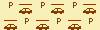 | 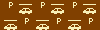 |
| Parking (Trucks) |  |  |
| Airport |  |  |
| Cafe, restaurant, supermarket |  |  |
| Educational center |  |  |
| Health center |  |  |
| Industrial complex |  |  |
| Quarry |  |  |
| Runway |  |  |
| Commercial area |  |  |
| Residential area |  |  |
| Danger area |  |  |
| Retail |  |  |
| Building |  |  |
| Dam |  |  |
| Village green |  |  |
| Nature reserve |  |  |
| Park, garden, recreation ground |  |  |
| Golf course |  |  |
| Sports |  |  |
| Cemetery |  |  |
| Meadow |  |  |
| Park |  |  |
| Picnic |  |  |
| Garden |  |  |
| Historic site |  |  |
| Pedestrian area, square |  |  |
| Farm, farmyard |  |  |
| Zoo |  |  |
| Beach |  |  |
| Prison |  |  |
| Supermarket |  |  |
| Power station |  |  |
| Camping site |  |  |
| Car retail/repair |  |  |
| Scree |  |  |
| Water body (see, reservoir, bay, river,...) |  |  |
| Intermittent water body |  |  |
| Marina, water park |  |  |
| Land |  |  |
| Glacier |  |  |
| Orchard, plantation |  |  |
| Scrub |  |  |
| Wood, forest |  |  |
| Coniferous |  |  |
| Broad-leaved |  |  |
| Mixed |  |  |
| Palm |  |  |
| Marsh, wetland |  |  |
| Tundra |  |  |
Points of Interest
| Places | Day | Night |
|---|---|---|
| Country capital, city > 1,000,000 inhabitants |  |  |
| City > 750,000 inhabitants |  |  |
| City > 500,000 inhabitants |  |  |
| City > 250,000 inhabitants |  |  |
| City > 100,000 inhabitants |  |  |
| City > 50,000 inhabitants |  |  |
| City > 10,000 inhabitants |  |  |
| Village > 5,000 inhabitants |  |  |
| Village > 1,000 inhabitants |  |  |
| Suburb |  |  |
| Hamlet |  |  |
| Restaurants | Day | Night |
|---|---|---|
| Restaurant |  |  |
| American, burger |  |  |
| Asiatic, deli |  |  |
| Barbecue, kebab |  |  |
| Chinese |  |  |
| Fast food |  |  |
| Italian |  |  |
| Mexican, Spanish |  |  |
| Pizza |  |  |
| Cafe |  |  |
| French |  |  |
| Spanish |  |  |
| Health Services | Day | Night |
|---|---|---|
| Hospital |  |  |
| Doctors |  |  |
| Pharmacy |  |  |
| Transport | Day | Night |
|---|---|---|
| Airport |  |  |
| Aerodrome |  |  |
| Helipad |  |  |
| Station |  |  |
| Taxi stop |  |  |
| Bus stop |  |  |
| Tram stop |  |  |
| Car Services | Day | Night |
|---|---|---|
| Gas station |  |  |
| Gas station with convenience On the map the name will be followed by + symbol |  |  |
| Gas station, high output pumps for trucks On the map the name will be followed by * symbol |  |  |
| EV charging point |  |  |
| Parking |  |  |
| Car rental |  |  |
| Car repair |  |  |
| Car/tyre shop |  |  |
| Car wash |  |  |
| Other Services | Day | Night |
|---|---|---|
| Information |  |  |
| Toilets |  |  |
| Telephone/Internet |  |  |
| Drinking water |  |  |
| Recycling |  |  |
| Lodging | Day | Night |
|---|---|---|
| Hotel |  |  |
| Hostel, hut, guest house |  |  |
| Wilderness hut |  |  |
| Camp site |  |  |
| Other Points of Interest | Day | Night |
|---|---|---|
| Motorway exit |  |  |
| Library |  |  |
| Kindergarten, school, gollege, university |  |  |
| Place of worship |  |  |
| Bar, pub |  |  |
| Cinema |  |  |
| Golf course |  |  |
| Supermarket |  |  |
| Bank, ATM (see below) |  |  |
| Bicycle shop/rental |  |  |
| Border control |  |  |
| Survey point |  |  |
| Power tower |  |  |
| Antenna, tower |  |  |
| Peak |  |  |
| Cave |  |  |
| Museum, monument |  |  |
| Barriers | Day | Night |
|---|---|---|
| Gate |  |  |
| Bollard |  |  |
| Cattle grid |  |  |
| Lift gate |  |  |
| Cycle barrier |  |  |
| Stile |  |  |
| Kerb |  |  |
| Entrance |  |  |
| Block |  |  |
| Banks | Day | Night |
|---|---|---|
| Bank |  |  |
| LCL |  |  |
| Oschadbank |  |  |
| TD Canada Trust |  |  |
| Bradesco |  |  |
| NatWest |  |  |
| Bankinter |  |  |
| Bankia |  |  |
| 4b |  |  |
| Euro 6000 |  |  |
| Servired |  |  |
| Sberbank |  |  |
| Euronet |  |  |
| Privatbank |  |  |
| Sparkasse |  |  |
| La Banque Postale |  |  |
| Swedbank |  |  |
| SEB |  |  |
| Postbank |  |  |
| Rabobank |  |  |
| Volksbank |  |  |
| Santander |  |  |
| Crédit Agricole |  |  |
| Raiffeisenbank |  |  |
| Bank of America |  |  |
| HSBC |  |  |
| Caisse d'Epargne |  |  |
| Wells Fargo |  |  |
| CaixaBank |  |  |
| BBVA |  |  |
| Barclays |  |  |
| Chase |  |  |
| Banco do Brasil |  |  |
| Crédit Mutuel |  |  |
| Deutsche Bank |  |  |
| Société Générale |  |  |
| Commerzbank |  |  |
| BNP Paribas |  |  |
| Scotiabank |  |  |
Comments (5)
Here in the legend the dirt road is marked as two parallel dotted lines, on wikiloc there is always and only one line, longer brown, shorter red: has the way of indicating the paths changed?
The numbers in brackets means width in meters: X M. M should be lower case, but Garmin software capitelizes it. Widths should be introduced in OSM database without units, but if someone add an "m" then you'll see a double "m" in the map.
Currently there's no way to distinguish them. In most places a secondary road is supposed to be paved, but I know that's not true in all countries.