Maps for Garmin based on OpenStreetMap
Known issues
Garmin maps format is not public, so map generation process (done with mkgmap) is based in reverse engineering. As format has not been completely deciphered yet, there's still a number of problems affecting the maps. They have the advantage that data on them are most probably more up to date than commercial ones, although in some areas coverage is lower. Another great advantage is that anyone can complete or correct missing or wrong data. Below there is a list of known issues regarding the use of the maps.
- Address search: in order to find a given street using 'Search by address' option of the GPS it is necessary to type the name of the street exactly as it is on the map, e.g. 'Calle de los Derechos Humanos' (Human Rights Street). It may be a problem for languages like Spanish or French, in which the name of the way is preceded by the type of way: Avenida de América, Paseo de la Castellana, etc. as it will be difficult to know how the name of a street is in the map: it may be Calle Derechos Humanos, C/ de los Derechos Humanos, Avenida América, etc.
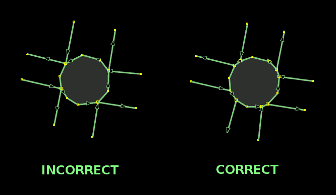
To avoid this, some changes are introduced that let you omit the type of way and also particles before the main part of the name. For the examples above, typing “Derechos Humanos”, “América” or “Castellana” will be enough. Some irrelevant words common at the end of street names, like Avenue, Street, Road (English), Strasse, Weg (German), kalea, bidea (Basque), etc. are also removed. - Roundabouts exit number: if a way entering a roundabout shares a node with an exiting way, that exit is not taken into account for the 'Take exit # to the right' instruction, although on screen it is correctly displayed. In fact, it is caused by errors in the data used to generate the map, and must be fixed on OpenStreetMap data.

- Advanced functions: some advanced functions, such as lane indication, on screen speed limit display, crossing search, etc. don't work.
- Topographic maps on MapSource: contour lines behavior in MapSource is quite variable, some times they are displayed and some times they are not, without a known motive, just showing the number that indicates the height but not the line. However, although they are not seen, they are there and can be used, for example, to calculate a route profile (Edit menu->Route Properties->Show Profile...). On BaseCamp and QLandkarte GT this problem doesn't occur.
If you detect any other problem in the maps, other than those due to errors or lacks in OpenStreetMap data, please use the comments at the en of this page to report it.
You can leave your comments on this page below:
Add Comment
This policy contains information about your privacy. By posting, you are declaring that you understand this policy:
- Your name, rating, website address, town, country, state and comment will be publicly displayed if entered.
- Aside from the data entered into these form fields, other stored data about your comment will include:
- Your IP address (not displayed)
- The time/date of your submission (displayed)
- Your email address will not be shared. It is collected for only two reasons:
- Administrative purposes, should a need to contact you arise.
- To inform you of new comments, should you subscribe to receive notifications.
- A cookie may be set on your computer. This is used to remember your inputs. It will expire by itself.
This policy is subject to change at any time and without notice.
These terms and conditions contain rules about posting comments. By submitting a comment, you are declaring that you agree with these rules:
- Although the administrator will attempt to moderate comments, it is impossible for every comment to have been moderated at any given time.
- You acknowledge that all comments express the views and opinions of the original author and not those of the administrator.
- You agree not to post any material which is knowingly false, obscene, hateful, threatening, harassing or invasive of a person's privacy.
- The administrator has the right to edit, move or remove any comment for any reason and without notice.
Failure to comply with these rules may result in being banned from submitting further comments.
These terms and conditions are subject to change at any time and without notice.


Comments (65)
In Basecamp it seems to be not possible to set up avoidances like "routing without Highway". No matter which avoidances I choose, the route stays always same.
This would be needful for Motorcycle Routing.regards,
Michael
Transferring only OSM Maps without Contour lines worked.
Thanks for your help.
You must install contour lines separately (they are available at downloads page) and also select contour lines tiles along with base map tiles before sending map to device.
1. Basecamp MapInstaller (newest version) doesn't work. How can I proceed? I tried to reinstall an earlier version, but it doesn't work anyhow. Meanwhile I downloaded the "gmapsupp" directly on the device. We'll see how it works using the route from the laptop.
2. Map and nature: There is an official working border crossing from Botswana to Namibia in Mamuno(BOT)/Buitepos(NAM), but the routing tool determins it as closed?
Regarding 2, I have tried routing in MapSource, and it works for me (car/motorvehicle mode).Anyway, there were some tags in the roads crossing border that could be causing the problem. I have removed them. Please try next version of the map and report back.
I would really like to build maps with Chinese characters, so your message is welcome. I did some tests to build such maps time ago, but was not able to test them on my computer/device and didn't receive any feed-back about them either. If you could test maps and report about them I would be pleased to work on them again. If you want to collaborate, please send me an email using "Contact" link.
I'm aware of such problem in some countries. I started to correct it, but updating contour lines requires a lot of time. I'll try to update Malaysia contour lines next.