
Maps for Garmin based on OpenStreetMap


What can you do with the maps?
Maps can be installed on Garmin GPS's, as routable maps that will give you turn by turn instructions to go to a given place (depending on device's specifications). It can also be seen in your computer, where you can calculate your routes, using MapSource or BaseCamp Garmin software, or the open source programs QLandkarte GT or QMapShack. With the topographic maps you can also calculate profiles for your routes.
Viewing the maps in your computer:
Linux: you can use Qlandkarte GT, its sucessor QMapShack or MapEdit++ (the latter is for Windows, but works fine under wine). You can also use MapSource with wine and load maps running the auto-install file (
wine OpenStreetMap_*.exe) or copying *.gmap folder into .wine/drive_c/ProgramData/GARMIN/Maps/Windows: maps can be used with the open source programs Qlandkarte GT, its sucessor QMapShack or MapEdit++ or with Garmin software MapSource or BaseCamp.
In order to load maps in MapSource or BaseCamp, you just have to run the file named «OpenStreetMap_*.exe» and follow wizard steps. It is important not to change installation path (typically C:\ProgramData\Garmin\Maps in Windows 10), otherwise BaseCamp will not be able to read map.
Mac: you will need Garmin programs BaseCamp (to open maps, plan routes, etc.) and MapInstall and MapManager (to send maps to GPS) installed in your system. To see the maps on BaseCamp you must proceed as follows:
- Open the file you have downloaded in a “Finder“ window. Within it, you'll find a folder called “OpenStreetMap Country Type.gmap“.
- In another “Finder“ window, go to “Applications“, right click on “Garmin BaseCamp“ icon and select “Show Package Contents” option.
- “Contents“ folder will show up and, within it, “Resources“ folder. Move “OpenStreetMap Country Type.gmap“ folder into “Resources“. Once done, map will be ready to be used in BaseCamp.
Installing the maps in a GPS:
First of all, download file for GPS of the country you want from Downloads page and unzip it. You'll get a file called gmapsupp.img. The easiest way to have the map in your Garmin device is copying file gmapsupp.img in the external SD/micro SD card of the device, within a folder called «Garmin» (create it if it doesn't exist); in some models gmapsupp.img file must be copied into «Map» folder instead of «Garmin» folder (note «Map» folder may be hidden). This method is also recommeded because in case of any problem with the map, removing the card and restarting device will be enough to solve it. To copy it use a card reader (faster) or connect your device to the computer with a suitable cable, in 'Mass storage' mode (slower).
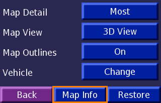
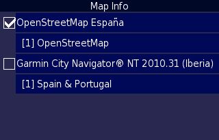
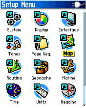
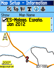
Once copied, switch on the GPS, go to Settings>Map>Map Info and enable OpenStreetMap map. The way to activate the map varies from one model to other:
nüvi 300: | |
|
Legend HCx: |
|
|
|
|
If you don't have an external card, you can use any of the free programs sendMap or Qlandkarte; you can also use MapSource or BaseCamp from Garmin. In the last cases, you first have to load the map in MapSource/BaseCamp as explained above.
Using on Android devices:
If you want to see maps from this site on your Android mobile device, you can use OruxMaps app. For that, follow the steps below:
- Download file for GPS of the country you want from Downloads page and unzip it. You'll get a file called gmapsupp.img. You can change the name to something more descriptive, such as MyCountry.img.
- Copy that file into OruxMaps maps folder, by default oruxmaps/mapfiles/.
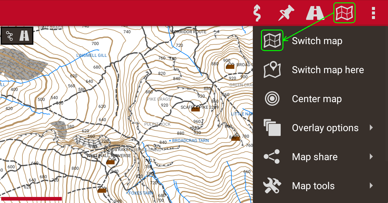
- Open OruxMaps app, click on «Switch map» button and select previously saved file.
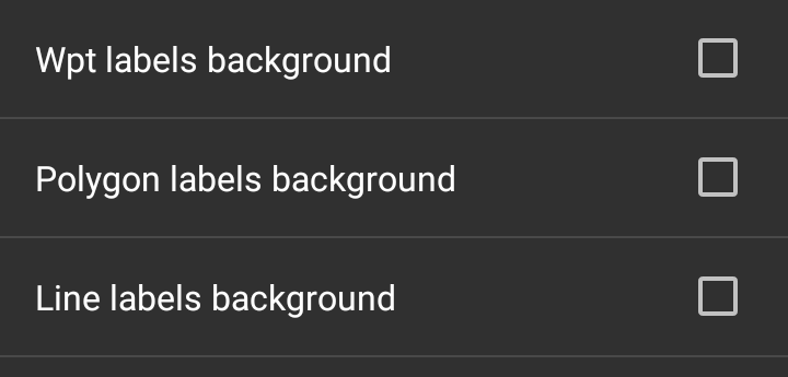
- For a better visualization of maps, it is recommeded to go Global settings->Maps->Garmin maps settings, and uncheck Wpt labels background, Polygon labels background and Line labels background boxes.
- Note: these maps are not routable on OruxMaps.
You can leave your comments on this page below:
Add Comment
Insert Bullet List
Please enter at least one item.
Item:
Item:
Item:
Item:
Item:
Insert Numeric List
Please enter at least one item.
Item:
Item:
Item:
Item:
Item:
Insert Link
Please enter the link of the website
Optionally you can add display text
Insert Email
Please enter the email address
Optionally add any display text
Insert Image
Please enter the link of the image
Insert YouTube Video
Please enter the link of the video
Image Upload
Privacy Policy
This policy contains information about your privacy. By posting, you are declaring that you understand this policy:
- Your name, rating, website address, town, country, state and comment will be publicly displayed if entered.
- Aside from the data entered into these form fields, other stored data about your comment will include:
- Your IP address (not displayed)
- The time/date of your submission (displayed)
- Your email address will not be shared. It is collected for only two reasons:
- Administrative purposes, should a need to contact you arise.
- To inform you of new comments, should you subscribe to receive notifications.
- A cookie may be set on your computer. This is used to remember your inputs. It will expire by itself.
This policy is subject to change at any time and without notice.
Terms and Conditions
These terms and conditions contain rules about posting comments. By submitting a comment, you are declaring that you agree with these rules:
- Although the administrator will attempt to moderate comments, it is impossible for every comment to have been moderated at any given time.
- You acknowledge that all comments express the views and opinions of the original author and not those of the administrator.
- You agree not to post any material which is knowingly false, obscene, hateful, threatening, harassing or invasive of a person's privacy.
- The administrator has the right to edit, move or remove any comment for any reason and without notice.
Failure to comply with these rules may result in being banned from submitting further comments.
These terms and conditions are subject to change at any time and without notice.
{"commentics_url":"\/\/alternativaslibres.org\/comments\/","page_id":15,"enabled_country":true,"country_id":0,"enabled_state":false,"state_id":0,"enabled_upload":true,"maximum_upload_amount":3,"maximum_upload_size":5,"maximum_upload_total":5,"captcha":false,"captcha_url":"","cmtx_wait_for_comment":"cmtx_wait_for_comment","lang_error_file_num":"A maximum of %d files are allowed to be uploaded","lang_error_file_size":"Please upload files no bigger than %.1f MB in size","lang_error_file_total":"The total size of all files must be less than %.1f MB","lang_error_file_type":"Only image file types are allowed to be uploaded","lang_text_loading":"Loading ..","lang_placeholder_country":"Country","lang_placeholder_state":"State","lang_text_country_first":"Please select a country first","lang_button_submit":"Add Comment","lang_button_preview":"Preview","lang_button_remove":"Remove","lang_button_processing":"Please Wait.."}
{"commentics_url":"\/\/alternativaslibres.org\/comments\/","language":"english"}
Comments (1)
These are my questions
1) the formatting is not read by the GPS. It erases all data and formats.
2) The GPS format is not read by my Mcbook pro.
3) Map installer is not reading gmapsupp.img or contur imageSo please advise how do I install Scandinavia maps on my Garmin Drive 53?